Square 551, 1969 Plans
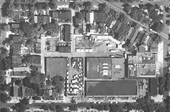
The point of this site is to share information about the history of the neighborhood. I have a pile of documents relating to this neighborhood and Shaw as a whole. I should try to get more documents such as the 1969 report I found out. Though it doesn’t say a lot, it does talk about the one square, Sq. 551, which is bounded by R , Florida Ave, 1st, Q and 3rd Streets. Before the Florida Avenue park and the Northwest Cooperative, there were individual homes, a dairy and the old Mt. Sinai church. According to the report the houses on the block were too dilapidated for repair and were best torn down, the diary produced too much truck traffic, and the whole block (with the exception of the Mt. Sinai property) should be redeveloped. It appears Mt. Sinai obtained the properties between it’s old building and the corner at 3rd and Q, where the newer building sits today. This may be of interest to members of Mt. Sinai and residents of the Co-Op.
The document is from the National Archives and Records Administration in their collection relating to the National Capital Planning Commission.
Unchanged structures
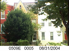
The devil is in the details and I'm collecting some details that may disappear. In the past few months, when I remember to do it, I have been collecting images from one of the District of Columbia databases. These are exterior shots of houses taken in 2004. It is now 2014, ten years later and so I'm concerned that government may update these images. 2004 is a good enough year for my purposes. Considering that at that time not a lot of houses underwent a lot of changes, many have remained unchanged and look pretty much the same. But some others, with the rise of real estate prices, had additions placed on top ("pop-ups"). It is good to have a resource to see houses prior to possible changes.
Link- DC GIS Master Address Repository
Where did everybody go?
#truxtoncircledc population in 1940= 8235, #truxtoncricle pop # in 2010= 3028. Where'd everybody go? #dchistory #uscensus .
— Mari Inshaw (@TruxtonTwit) August 1, 2013
A few months ago I posted on my Twitter page, yes, this its has a Twitter page, the census numbers for the neighborhood.
In 1940 the number of residents topped at about 8,235. The last census taken found 3,028 residents. That's way less than half of the 1940 numbers. Why? I have several theories, one being that we don't live that way anymore. There aren't a lot of large families under one roof. People have roommates, no longer keeping boarders in the house. Families who rent, usually rent separate units that may be in the basement, or a completely separate floor, not several rooms in the same house. Boarding houses are a rare thing in DC in the 21st century. No we 21st century residents are different. We have smaller families, or we live alone. We don't crowd into bedrooms and we don't rent out extra rooms often for income.
I should compare number of dwelling units, because I think the numbers comparing 1940 and 2010 won't be terribly different. If the number of units aren't too different, then what does that say about housing and density?
1929 Street Directory
Some time ago I looked in Boyd's City Directory to confirm addresses in the 1930 Census. Sometimes the addresses and names matched up, sometimes they did not. The city directories are helpful tools in seeing who lived at your address. Currently my copy is over at Google Docs (follow link). The third page in the PDF document is First Street NW.
Lucky C. Young
This was originally published on the Inshaw Blog on January 9, 2013.
I swear that I've written about Lucky C. Young before but I have not found him on my blog. Maybe it was one of those posts that never made it past the draft stage.
There are many houses in Truxton Circle that have housed more than one household. Several homes were built as two flat units, so when I was cleaning up data for the 1930 census it wasn't so unusual to have two households at 1203 New Jersey Avenue NW. What was unusual, and why I thought there was some clean up needed, one household was listed as Black and the other white. The first family were the African American Chambers family, with a father, mother and their 17 year old daughter. At the very end of the page were the Youngs, Lucky C. and his wife Estelle and they were clearly listed as white. Considering everyone else on the 1200 block of NJ Ave was Black, the Youngs didn't seem right, so I researched them.
I could not find anything on Estelle Young. She was 27 at the time and the census doesn't show how long she and Lucky were married.
Lucky C. Young was a different story. He was a driver, born in 1905 in South Carolina, however, he wasn't white. Later WWII records list him as a Negro widower, and a driver, so I knew I had the same person even though his race and marital status had changed. Between the 1930 census and getting enlisted, a 1937 city directory had him living at 1508 6th St NW, only a few blocks (walking distance) from his old NJ Ave digs. That ends what I could find using Ancestry.com's website.
Switching over to ProQuest (at fine Public Libraries everwhere) Lucky C. Young finds nothing but trouble. In 1950 he was caught up in an embezzlement court case involving the Capitol Cab Co. The case was dismissed. In 1964 his violent death was reported. He was shot October 10th near the unit or 100 block of Q St NW (nw vs ne is debatable) in his cab, a few blocks from his home at 47 Randolph Pl NW. November 19th he died at a hospital. He is buried at Arlington Cemetery and his murder was unsolved. Looking at the 1960 City Directory he listed there with his 2nd(?) wife Irene B. Young.
What I find very interesting about Mr. Young are his movements around the neighborhood. He doesn't stay put, but he stays 'around'. Cities are dynamic place with people constantly on the move. He was in DC, as far as I could tell, for decades, but not in the same place. So I wonder what or even how does this case reflect on the lives of other Washingtonians.
History of Sq. 520
This will be cross posted at http://blog.inshaw.com/2013/02/history-of-sq-520.html
I looked back at my history of Sq. 618,
the block bounded by N St, New York Ave and 1st St. I see the problem
with it, I tried to say too much. That's the problem with the census
data and looking at the detailed changes over time, there is just too
much. So I decided to switch it up and tell a tale where the info isn't
that new to me and I can try to keep the stories simple. Try.
In 1880
there were only 6 people listed as living on the square. There was a
carpenter living alone at 305 Q St and the Miller family at 1600 3rd St
NW. The Franco-Prussian Miller family interests me (not as much as the
100% German Glorius family on Sq. 519), because the head, John Miller's
name is shown as owning most of Sq. 520 and a good portion of Sq. 509E.
You can see it on the map shown here, where a tiny bit of the
neighboring square is shown. At the time of the 1880 census Mr. Miller
had reached the ripe old age of 77, so you can imagine by the 1900
census, he was very, very dead.
In
1900 the whole block had changed, like most blocks in the Truxton
Circle area. Notice in the 1887 map there are mostly of empty lots, by
1903 (the date for this map) 4th St had filled out and there are several
new structures on 3rd St. The population changed from just 6 people to
about 179. As time goes on the few empty lots continue to fill out an
there are more people.
There is a thought that this is a place where
families put down roots, however, in the case of Sq. 520 (and I believe
with many blocks) most people are just passing through. I took the names
of everyone from the 1900 to 1940 census and looked for similar names
and duplicates across the censuses. There are some people who are found
in 2 censuses. Very rare is it to find someone who has managed to stick
around for 3 or more with the same address. One of these rarities is
Mrs. Mary Davis who lived at 1623 4th St NW from the 1910 to 1930,
possibly 1940. Possibly, because the info doesn't match up, as I suspect
it may be a same named relative or she was lying about her age. In 1910
she was 38 years old and living with her husband of 13 years, John,
mortgage free. There is no change in 1920, except she's 48. By 1930 John
is no longer in the picture and she is a widow, working as a matron for
the federal government. But here her age changes, she's now 55. By this
time she should be 58 years old. In 1940 we have a Mary Davis living at
1623, but she is listed as being 60, when she should be 68 years old.
It is not uncommon for a woman to lie about her age.
Take it and Use it
I love hearing from residents that you've used this website and learned a little something about where you live, be it your house or just learning about your street. Most people look at the history of their own address, and that is good too. What really impressed me this week was someone took the census data and mapped it out so people can see the changes in population, race, age and gender from 1880 to 1940 by going to http://www.unit201.net/tc1/ .
Mapping is not one of my talents, so I am very happy when others take their talents and make use of this data. If you have made use of this website and it is something that can be shared with everyone, please contact me at mari at inshaw dot com.
Truxton Circle Project at the DC Humanities Council Presentation
Tomorrow, December 6th from 6:30 to 8:30 at the All Souls Unitarian Church at 1500 Harvard St NW (Columbia Heights metro). This and other DC Humanities grantees will show off what we've been doing this summer. Of course you can see what The Truxton Circle Neighborhood Genealogy Project (with North Capitol Main Streets, Inc) has been up to right here. But there you will have an opportunity to ask questions. Please see http://www.wdchumanities.org/ for more information.
All Mapped Out
Well there are now about 100 maps on the Truxton Circle site ranging from microfilm and hard copies found in the Washingtonia Division at the Martin Luther King DC Public Library at Gallery Place to aerial maps created by the U.S. Geological Survey (a government agency) in the 1950s.
Whereas the census data can tell about the social and demographic changes of the neighborhood the maps show changes in property lines, streets, courts and alleys the come and go, as well as houses that do the same. See Square 519 (bounded by Florida Ave, 3rd, R and 4th Sts NW) that begins with the German Glorius family in 1887 taking up the whole block and as we move into the 20th century the family has divided the block into lots and later sells the majority of the property to Harry Wardman, a developer. We also see blocks that in no way resemble their current layout. From the start Square 551changes, where there were a few houses here and there in 1887, it builds up in 1903 and 1909 with more housing along 1st St NW where there were none and more housing appears in the alleys. By 1924 a bunch of warehouses and between 1951-1952 we see trucks and a small light industrial area. There is more to the story, but here it's just the beginning to learning about the thousands of stories this neighborhood holds.
All Squares have 1940 data
There are still some corrections to be made but a majority of the data for 1940 is up and available. I still need to clean up and make available some data from the 1930 census regarding Square 554 and there are at least a 100 lines in the 1940 census where there was no house or street address for people. That will require more research. But for the most part, there is a high chance that if you are looking for your home and your street there will be data. If there isn't please contact me.